Services
Services
Filters
Ready to Pioneer Your Growth?
Share your goals in the form below and let’s co-create what’s next.
Comprehensive property documentation: aerial drone exterior inspection plus FPV interior walkthrough capturing every room, hallway, and feature in continuous flight — then delivered as an annotated PDF report with key findings flagged. Built for total-loss claims, pre-policy documentation, and underwriting reviews where speed and detail both matter. Pricing scales with property size; range $400-$650 (anchor $475-$525) confirmed at scoping. FAA Part 107 certified pilot. 50% deposit required to schedule.
Aerial drone inspection of a property's exterior — roof, siding, gutters, chimney, and surrounding grounds. Delivered as a digital photo set with key findings flagged. Built for adjusters, agents, and underwriters needing fast, safe exterior documentation. Pricing scales with property size and complexity; range $225-$350 confirmed at scoping. FAA Part 107 certified pilot. 50% deposit required to schedule.
Annual content retainer for hotels and resorts — 4 quarterly reshoots over 12 months capturing the property in every season. Includes seasonal cinematic refreshes, social cuts, and hero stills delivered each quarter. Built for properties that need year-round fresh content. 4K delivery with licensed music. Annual price billed at booking; 50% deposit secures the schedule.
The flagship resort marketing package: full property cinematic tour, lobby reel, 3 suite/room showcases, exterior aerial set, 5 hero stills, and 3 short-form social cuts. Built for resorts running a seasonal campaign or full rebrand. 4K delivery with licensed music. 50% deposit required to schedule shoot.
A 30-45 second FPV showcase of a single suite or room category — captures layout, finishes, and views in one continuous shot. Perfect for room-type listings on your booking site. Listed price is per room category. 4K delivery with licensed music. 50% deposit required to schedule shoot.
A 2-3 minute cinematic FPV tour covering the entire hotel or resort — lobby, restaurants, pool, spa, fitness center, signature suites, and exterior grounds. Built for booking sites, group sales decks, and OTA hero placements. 4K delivery with licensed music. 50% deposit required to schedule shoot.
Year-over-year content refresh — a return shoot 12 months after your initial booking to update your venue/facility footage with renovations, rebrands, or seasonal changes. Keeps your marketing current. 4K delivery with licensed music. Must be added to a base entertainment package.
FPV cinematic reel built for gyms, climbing facilities, sports complexes, indoor courts, and fitness studios. Captures equipment flow, member energy, and signature spaces in one continuous shot. Pricing scales with facility size; range $1,500-$2,000 confirmed at scoping. 4K delivery with licensed music. 50% deposit required to schedule shoot.
The flagship launch package for new entertainment venues, hotels, and hospitality openings. Includes pre-opening cinematic tour, opening-night live event coverage, multiple short-form social cuts, and hero stills. Built to make your launch impossible to scroll past. 4K delivery with licensed music. 50% deposit required to schedule shoot.
A 2-3 minute cinematic FPV tour through every key area of your hotel, entertainment facility, or hospitality venue — lobby, common areas, signature features, and exterior. Built for booking sites, websites, and group sales decks. Pricing scales with property size; range $3,000-$4,000 confirmed at scoping. 4K delivery with licensed music. 50% deposit required to schedule shoot.
Pricing per location when booking 2 or more taprooms or production sites — ideal for breweries with multiple locations or expanding brands. Each location receives its own 60-second cinematic flythrough. 4K delivery with licensed music. Listed price is per-location; minimum 2 required. 50% deposit required to schedule shoot.
A 90-120 second cinematic FPV tour from grain to glass — brewhouse, fermenters, packaging line, and taproom in one continuous shot. Built for brewery websites, distributor pitches, and brand storytelling. 4K delivery with licensed music. 50% deposit required to schedule shoot.
FPV cinematic flythrough captured during a live wedding or event — the energy, the crowd, the moment. Add to any base venue package. 4K delivery with licensed music. Must be booked alongside a base venue package. Live FPV requires a 50% deposit and signed event waiver.
Pricing per venue when booking 3 or more locations — ideal for venue groups, hospitality portfolios, and management companies. Each venue receives its own 60-90 second cinematic flythrough. 4K delivery with licensed music. Listed price is per-venue; minimum 3 required. 50% deposit required to schedule shoot.
Full venue cinematic tour plus 3 vertical short-form social cuts (Reels/TikTok format) and 5 hero stills pulled from the shoot. Built to keep your venue top-of-feed for engaged couples year-round. 4K delivery with licensed music. 50% deposit required to schedule shoot.
A 2+ minute cinematic FPV tour covering every key space your venue offers — ceremony, reception, getting-ready suites, exterior grounds, and signature features. Built for venue websites and pitch decks. Delivered in 4K with licensed music. 50% deposit required to schedule shoot.
Add-on for any FPV: Apartment Developers package. One additional unit walkthrough (studio, 1BR, 2BR, penthouse, etc.) shot in cinematic FPV and edited to match your hero piece. Add multiple to cover your full unit mix. Must be added to a base FPV: Apartment Developers package.
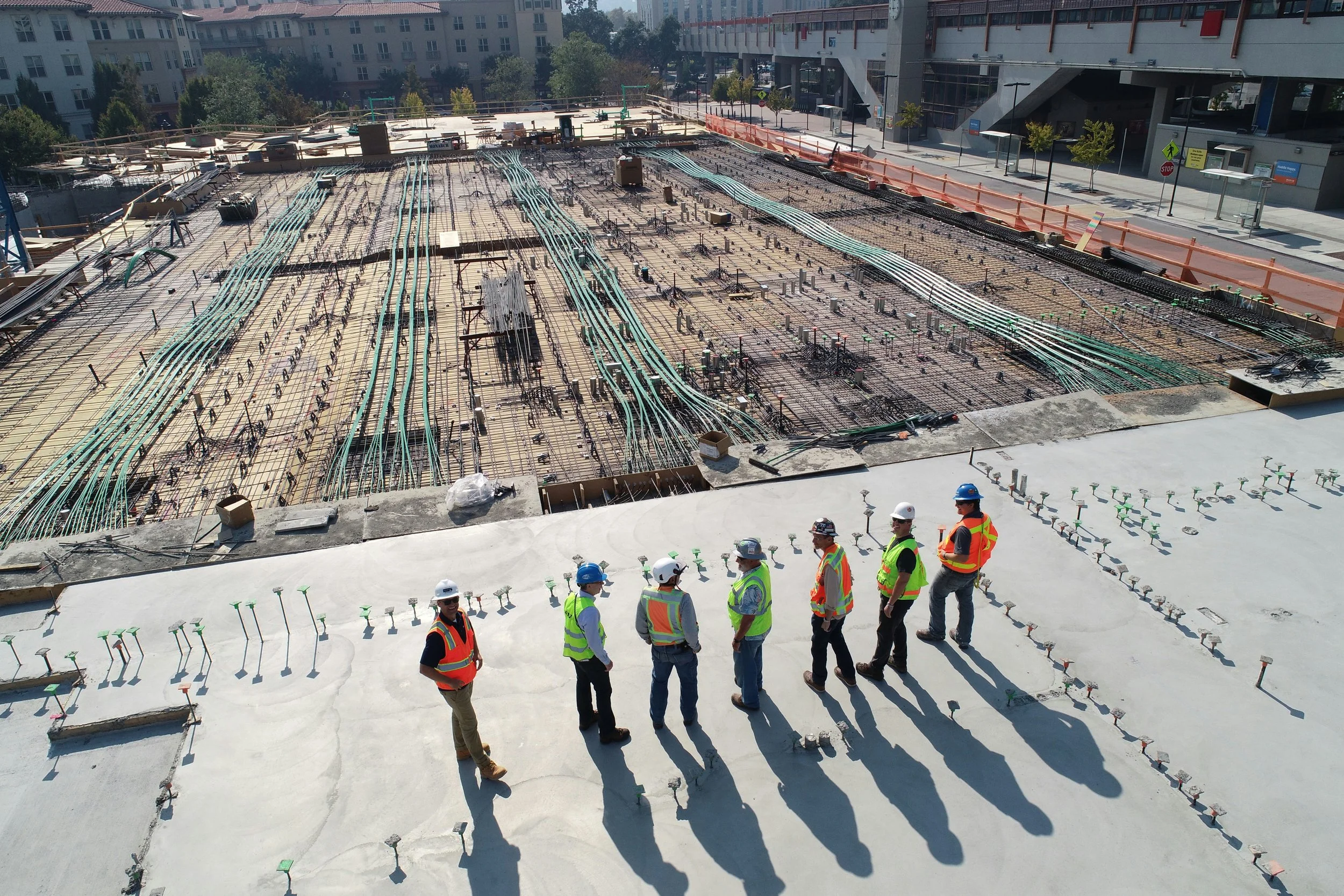
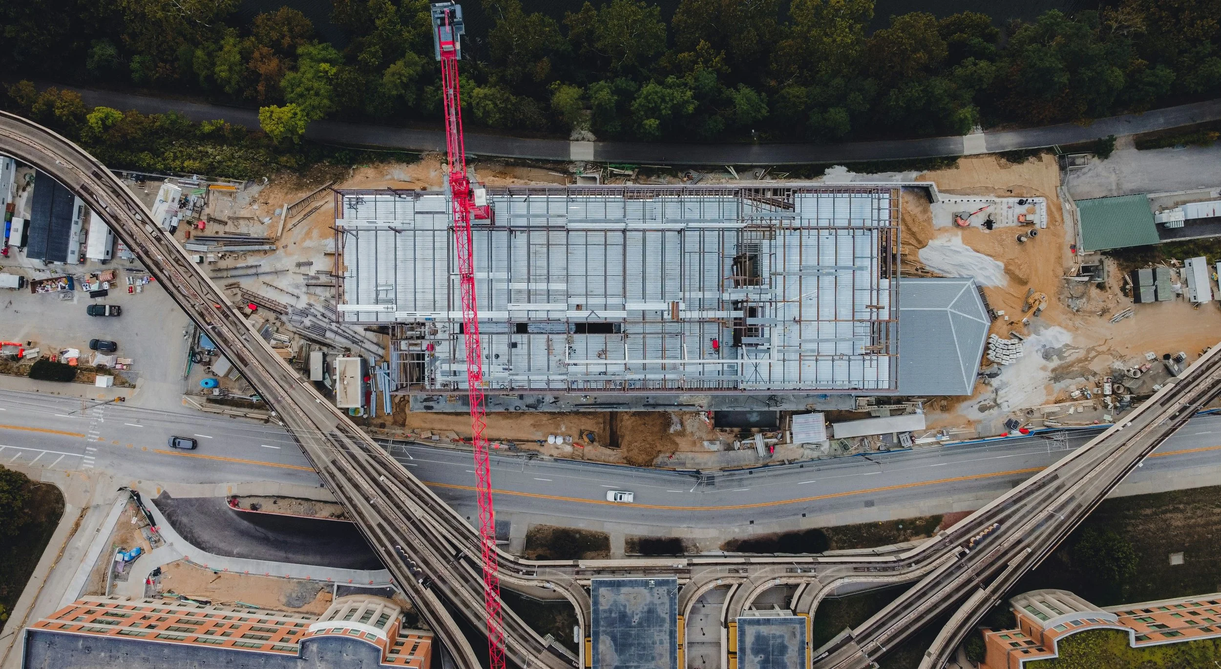
Six-month documentation bundle covering construction progress through final lease-up. Monthly aerial site progression captures, milestone time-lapses, and a final cinematic property tour at completion. Build investor decks, marketing reels, and lease-up assets in one engagement. Anchor pricing $8,000-$12,000 based on site size and visit cadence; $10,000 average. 50% deposit required to reserve.
Full lease-up content campaign for new or repositioned multifamily properties. Includes hero property tour (2-3 min), amenity flythrough, model unit walkthrough, exterior aerial reveal set, and a suite of vertical social cuts ready for paid + organic distribution. Designed to fill units faster. Music licensing handled by RFSI. Turnaround: 14-21 business days. 50% deposit required to reserve.
2-3 minute cinematic FPV tour covering the full property: arrival, lobby, key amenities, model unit, and exterior aerial reveal. The flagship asset for your leasing site, listing platforms, and brand campaigns. Music licensing handled by RFSI. Turnaround: 10-14 business days. Anchor pricing $2,500-$3,500 based on property scale; $3,000 average.
Add-on for any FPV Real Estate package. A scheduled return shoot at golden hour / blue hour / twilight to capture warm interior glow and dusk exterior reveal. Adds high-end magazine-style hero footage to your listing. Must be added to a base FPV: Real Estate package.
Add-on for any FPV Real Estate package. Expanded exterior aerial set: full property reveal pulls, multi-angle hero stills, and orbit shots of the home and lot. Great for properties with strong curb appeal or acreage. Must be added to a base FPV: Real Estate package.
Premium monthly retainer for top-producing agents and small teams. Covers 5 standard listings per month at $550 each (effective rate vs $750 a-la-carte). Each listing includes interior FPV walkthrough, exterior aerial passes, and one edited social cut. Priority scheduling. Unused listings do not roll over. 3-month minimum commitment. Cancel anytime after with 30 days notice.
Monthly retainer for high-volume agents. Covers 3 standard listings per month at $600 each (effective rate vs $750 a-la-carte). Each listing includes interior FPV walkthrough, exterior aerial passes, and one edited social cut. Unused listings do not roll over. 3-month minimum commitment. Cancel anytime after with 30 days notice.
Premium FPV cinematic package for luxury listings ($500K+). Includes interior FPV walkthrough, full exterior aerial reveal set, and two additional vertical social cuts (Reels / TikTok / Shorts). Dialed color grade and music selection appropriate for luxury market. Music licensing handled by RFSI. Turnaround: 5-7 business days.
60-90 second cinematic FPV flythrough of a single residential listing. Includes interior FPV walkthrough, exterior aerial passes, and one fully edited social-ready cut. Ideal for standard listings under $500K. Music licensing handled by RFSI for delivered cut. Turnaround: 5-7 business days.
Add-on for any event package. One additional sponsor-branded edit per sponsor (logo placement, tailored intro/outro, sponsor-specific moments highlighted). Add multiple to cover each sponsor on your activation. Must be added to a base Event & Concert Coverage package.
Branded corporate event coverage with same-week edited deliverables. Includes drone, FPV, and ground angles tailored to your activation, plus branded cuts ready for sponsors and social. $1,500 minimum. 50% non-refundable deposit required to reserve your date (fully non-refundable inside 14 days of the event). Outdoor bookings include a weather contingency / rain-date clause. Music licensing is the client's responsibility.
Multi-day festival or event coverage spanning 2-3 days. Includes daily edited recaps for end-of-day social delivery and a final long-form festival recap. Built for festivals, conferences, multi-day brand activations, and tour stops.
Included: 2-3 day on-site coverage, daily edited recaps, final long-form recap, social cuts, raw clip delivery. Starting at $12,000 (custom-quoted by scope, crew size, and deliverables).
Booking terms: $1,500 minimum on any event job. 50% deposit to reserve date (non-refundable inside 14 days of event). Outdoor events include weather contingency / rain-date language. Music licensing is the client's responsibility (RFSI does not clear or license music).
Full festival or major concert day coverage. Includes drone-to-stage hero reveal, multi-angle aerial and FPV, sponsor branded cuts, and multiple deliverables for marketing, social, and recap use.
Included: full event day on-site, drone-to-stage hero shot, multi-angle aerial + FPV, sponsor cuts, multiple final deliverables (long recap + social cuts + raw).
Booking terms: $1,500 minimum on any event job. 50% deposit to reserve date (non-refundable inside 14 days of event). Outdoor events include weather contingency / rain-date language. Music licensing is the client's responsibility (RFSI does not clear or license music).
Single-show concert and live performance coverage with multi-angle FPV and aerial drone work. Designed for venues, artists, promoters, and tour content. Captures crowd energy, stage hero shots, and high-impact reveal moments.
Included: single show coverage, multi-angle FPV + aerial, 2-3 minute recap edit, crowd hero shots, raw clip delivery.
Booking terms: $1,500 minimum on any event job. 50% deposit to reserve date (non-refundable inside 14 days of event). Outdoor events include weather contingency / rain-date language. Music licensing is the client's responsibility (RFSI does not clear or license music).
Full event-day coverage up to 8 hours, combining cinematic aerial drone work with FPV drone passes for high-energy footage. Ideal for weddings, corporate events, sporting events, and large gatherings.
Included: up to 8 hrs on-site, aerial + FPV drone coverage, edited highlight reel, 3 vertical social cuts, raw clip delivery.
Booking terms: $1,500 minimum on any event job. 50% deposit to reserve date (non-refundable inside 14 days of event). Outdoor Bookevents include weather contingency / rain-date language. Music licensing is the client's responsibility.
Single-drone event coverage for 3-4 hours, ideal for small gatherings, openings, ceremonies, and intimate events. Includes a 60-90 second edited highlight reel plus all raw clips.
Included: 3-4 hrs on-site drone coverage, single Part 107 pilot, 60-90 sec edited highlight, raw clip delivery.
Booking terms: $1,500 minimum on any event job. 50% deposit to reserve date (non-refundable inside 14 days of event). Outdoor events include weather contingency / rain-date language. Music licensing is the client's responsibility.
Stay informed on what's happening at your property — without ever leaving your desk.
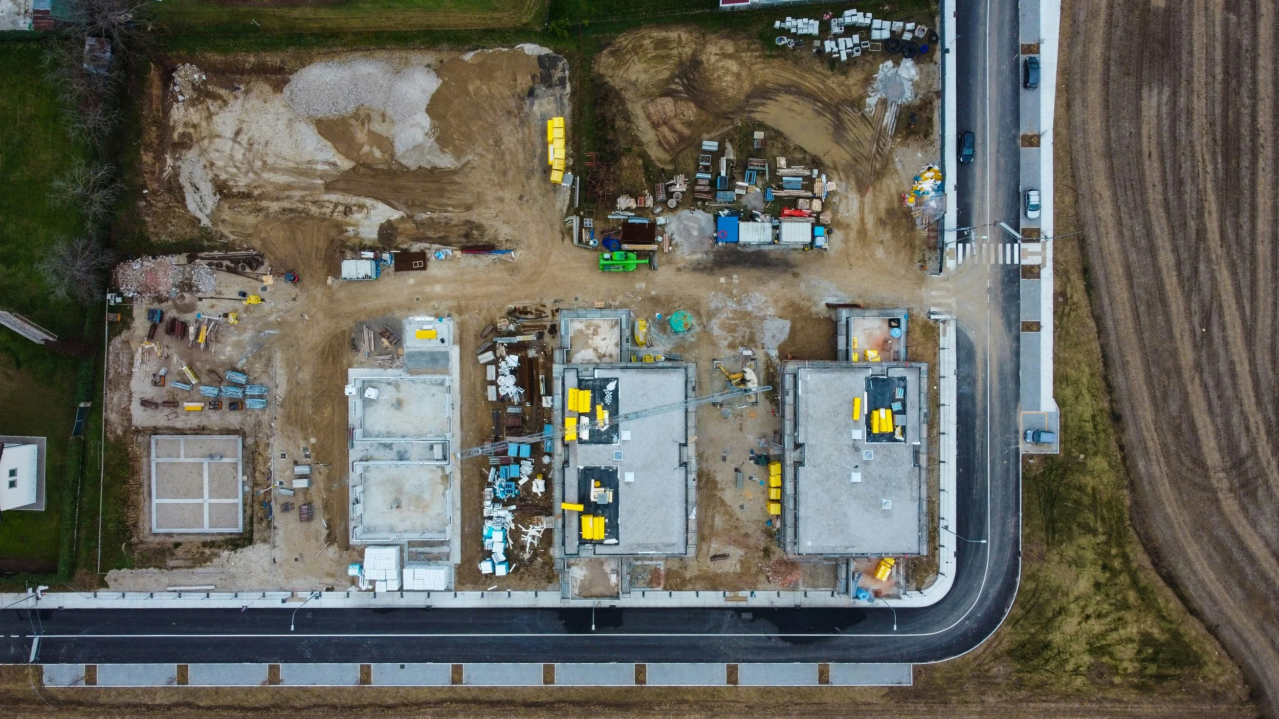
Site Watch Basic is RFSI's entry-level progress-monitoring package, built for property owners, developers, and contractors who need consistent aerial documentation at a regular cadence.
What's included:
Monthly aerial flight over your site
20–30 edited high-resolution aerial photos per visit
90-second cinematic flyover video — a polished aerial walkthrough of your site delivered each month
Private online delivery — all files delivered via shareable link within 3 business days of each flight
Best for:
Construction sites in the early-to-mid phase
Landowners monitoring clearing, grading, or infrastructure work
Developers who need documentation for lenders or investors
Anyone who wants consistent eyes on their property every month
More coverage, more confidence — twice a month, every month.
Site Watch Standard is built for active job sites and properties that move fast. With two flights per month, you get a clearer picture of progress, tighter documentation for stakeholders, and more touchpoints to catch issues before they become problems.
What's included:
2 aerial flights per month over your site
20–30 edited high-resolution aerial photos per visit
90-second cinematic flyover video delivered after each flight
Private online delivery — all files via shareable link within 3 business days of each flight
Best for:
Active construction sites with rapid week-to-week changes
Developers reporting progress to lenders or investors on a tighter cadence
Site managers who need documentation to coordinate crews or contractors
Any project where monthly just isn't often enough
Full-coverage site intelligence — every week, all month long.
Site Watch Pro is RFSI's most comprehensive monitoring package, designed for high-activity sites where documentation isn't just nice to have — it's a project requirement. With four flights a month and detailed reporting, you have everything you need to keep stakeholders informed, protect yourself from disputes, and track progress with precision.
What's included:
4 aerial flights per month — roughly weekly cadence
20–30 edited high-resolution aerial photos per visit
90-second cinematic flyover video delivered after each flight
Monthly progress report — a professionally compiled summary of site changes, delivered at the end of each month
Private online delivery — all files via shareable link within 3 business days of each flight
Best for:
Fast-moving commercial or residential construction projects
Developers with active lender reporting requirements
General contractors managing multiple crews or phases simultaneously
Projects where weekly documentation is a contractual or legal necessity
What's included:
20–30 edited high-resolution aerial photos delivered digitally
One (1) 90-second edited aerial video
Fast turnaround — files delivered within 48–72 hours
Licensed, insured FAA Part 107 pilot
Starting at $275 — final pricing based on project size, location, and deliverables.
What's included:
Full-length aerial video (custom length based on project scope)
Branded edit with color grade, music, and titles
Social media cut optimized for Instagram, LinkedIn, and YouTube Shorts
Licensed, insured FAA Part 107 pilot
Files delivered digitally within 5–7 business days
Starting at $950 — final pricing based on project size, location, and deliverables.
What's included:
Full-coverage orthomosaic map of your site
High-resolution GeoTIFF output
Accurate top-down perspective with measurable geometry
Licensed, insured FAA Part 107 pilot
Digital delivery within 48–72 hours
$30–$55/acre — pricing scales with acreage and site complexity.
What's included:
High-resolution photo documentation of the full roof surface
Close-up imagery of key areas — flashing, gutters, ridgeline, vents, and damage zones
Organized digital photo report delivered to your inbox
Safe, non-invasive inspection — no roof contact required
Licensed, insured FAA Part 107 pilot
Delivery within 24–48 hours
Starting at $295 — final pricing based on home size and roof complexity.
Need a full annotated damage report for insurance or contractor use? Ask about our Commercial Roof Inspection package for detailed findings with marked imagery.
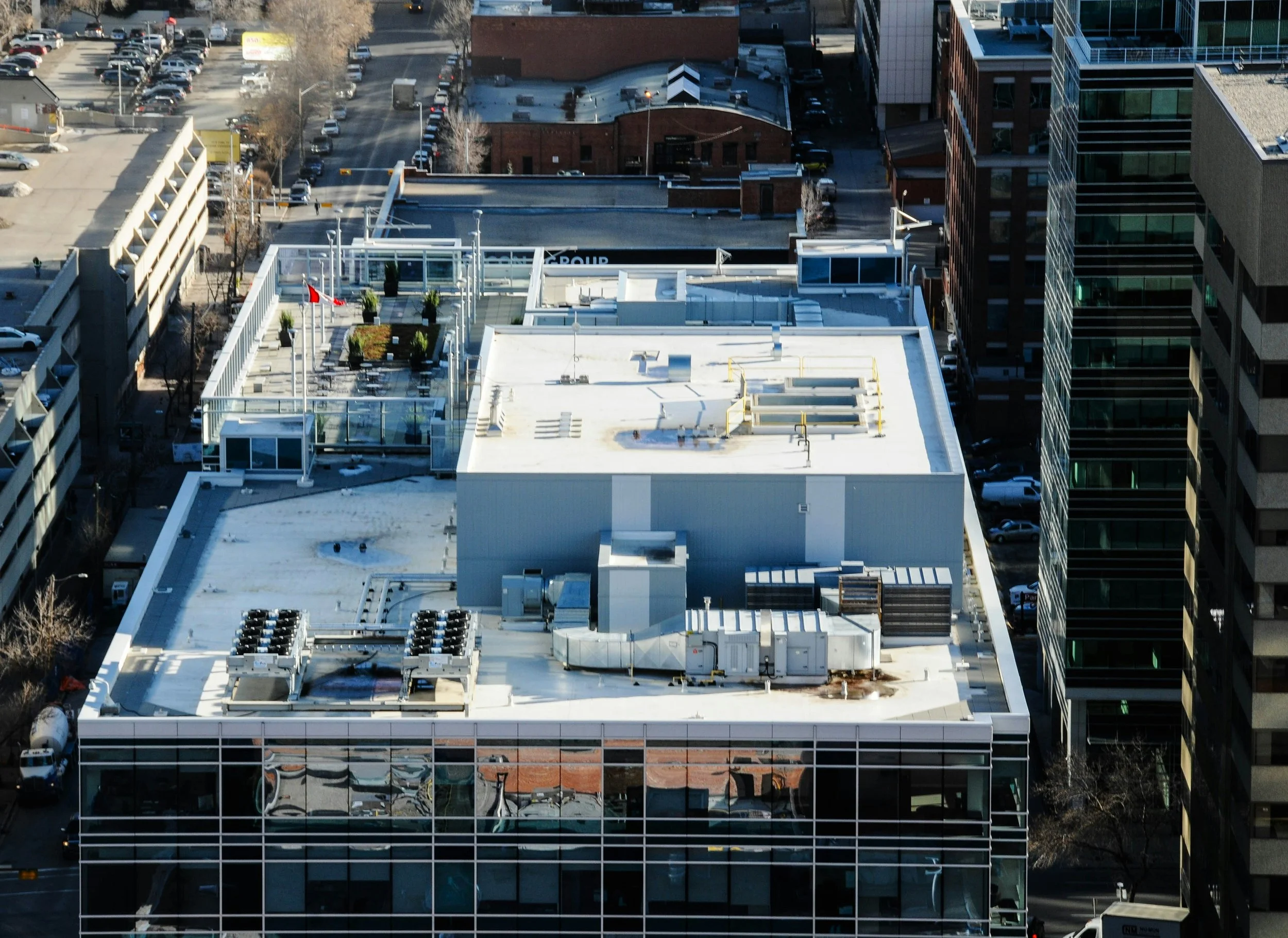
What's included:
Full-coverage high-resolution aerial imagery of the roof surface
Focused documentation of HVAC units, flashing, drains, penetrations, and wear areas
Annotated photo report with findings clearly identified
Digital delivery formatted for contractor and insurance use
Licensed, insured FAA Part 107 pilot
Delivery within 48–72 hours
Starting at $750 — final pricing based on building footprint, roof complexity, and number of mechanical units.

What's included:
Full exterior facade coverage on all accessible elevations
Close-up documentation of siding, windows, trim, soffits, fascia, and caulking
Annotated photo report identifying damage, wear, and water intrusion indicators
Digital delivery formatted for contractor, insurance, or property management use
Licensed, insured FAA Part 107 pilot
Delivery within 48–72 hours
Pricing:
Single-story residential or small commercial (up to ~2,500 sq ft footprint) — $350
Two-story or mid-size commercial (2,500–6,000 sq ft footprint) — $475–$600
Large commercial or multi-story (6,000+ sq ft, 3+ elevations) — $750+
Additional charges may apply for complex geometry, multiple buildings on one site, or same-day rush delivery
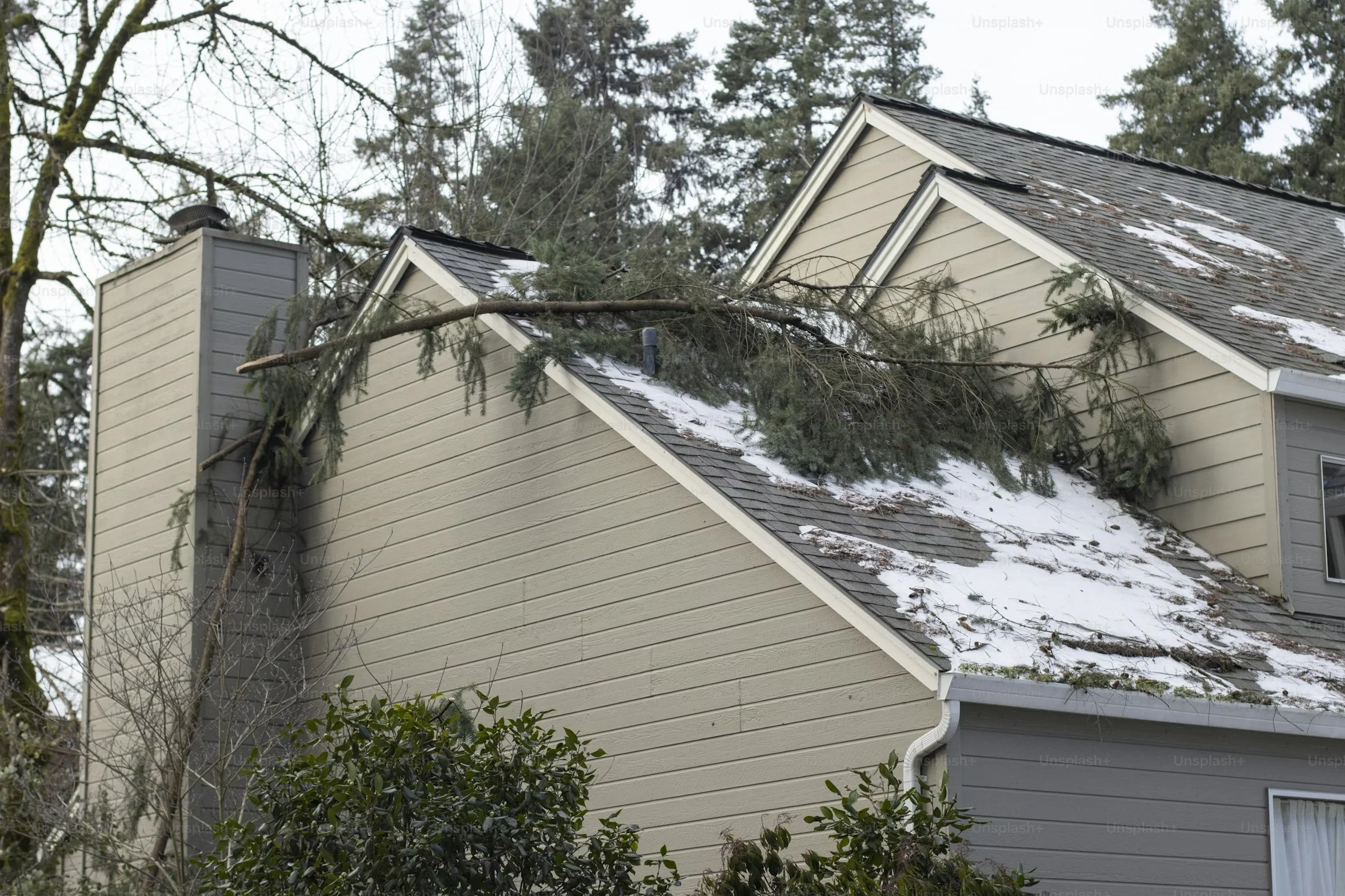
What's included:
Full aerial documentation of storm-affected roof, siding, and exterior surfaces
Close-up imagery of impact points, penetrations, and visible structural damage
Timestamped, geotagged imagery for claim validity
Annotated photo report organized for insurer and adjuster review
Licensed, insured FAA Part 107 pilot
Standard delivery within 24–48 hours
⚡ Rush Delivery Available — need documentation within hours of a storm? Rush scheduling is available for time-sensitive claims. Contact us directly to confirm availability.
Starting at $650 — final pricing based on property size, number of affected elevations, and turnaround requirement.
The sooner aerial documentation is captured after a storm event, the stronger your claim. Don't wait.
What's included:
High-resolution aerial imagery of road surfaces, shoulders, and drainage infrastructure
Documentation of pavement condition, cracking, subsidence, and surface wear
Bridge, culvert, and drainage structure photography
GIS-compatible deliverables (GeoTIFF, shapefiles, or KMZ upon request)
Organized asset report suitable for public works planning and budget justification
Licensed, insured FAA Part 107 pilot
Delivery within 5–7 business days
Starting at $700 — final pricing based on total route mileage, number of structures, and required deliverable formats.
Volume pricing available for townships and counties covering multiple road corridors or annual inspection contracts.
What's included:
Branded PDF report with your project details, annotated imagery, and findings summary
Marked and labeled aerial photos with damage zones, measurements, or points of interest called out
GIS exports available in GeoTIFF, KMZ, shapefile, or DXF formats upon request
Report formatted for professional distribution — ready to send to clients, insurers, or agencies
Revisions available upon request
Starting at $150 — pricing varies based on report complexity, number of annotated assets, and GIS deliverable format requirements.
Available as an add-on to any Red Feather Site Intelligence service. Mention this package at booking or request it after your flight.
No results match your search. Try removing a few filters.
Share your goals in the form below and let’s co-create what’s next.